TUTORIAL
Navigation Technologies for Future Autonomous Vehicles
Dr. Naser El-Sheimy is Professor and former Head of the Department of Geomatics Engineering, the University of Calgary. He holds a Tier-I Canada Research Chair (CRC) in Geomatics Multi-sensor Systems. His research expertise includes Geomatics multi-sensor systems, GPS/INS integration, and mobile mapping systems. He is the founder and president of METI Group.
Dr. El-Sheimy published two books, 6 book chapters and over 500 papers in academic journals, conference and workshop proceedings, in which he has received over 30 national and international paper awards. He supervised and graduated over 60 Masters and PhD students. He is the recipient of many national and international awards including the ASTech “Leadership in Alberta Technology” Award the Association of Professional Engineers, Geologists, and Geophysicists of Alberta (APEGGA) Educational Excellence Award. He also received the Schulich School of Engineering Research Excellence Award, the Schulich School of Engineering Teaching Excellence Award, The UofC Student Union Teaching Excellence Award, and 4 times the departmental teaching award, 2 times departmental research excellence award, and the department of Geomatics Engineering Graduate Educator Award. Dr. El-Sheimy was the president of Commission I on “Sensors and Platforms” of the International Society for Photogrammetry and Remote Sensing (ISPRS) from 2008 – 2012. He organized and participated in organizing many national and international conferences and chaired many conferences such as the USA Institute of Navigation Global Navigation Satellite Systems (GNSS). Dr. El-Sheimy is currently a member of the Editorial Board of Journal of Survey Review, MDPI Sensors, Journal of Applied Geodesy, and Coordinates.
There are three “pillars” that define the performance or usefulness of a navigation technologies – cost, accuracy, and continuity. Navigation is a field that has been fascinating humankind for thousands of years and these pillars have been evolving with new technological advancements. The current market in positioning and navigation is clearly dominated by GNSS. Besides being globally available, it meets two important pillars: accuracy and cost by providing the whole range of navigation accuracies at very low cost. It is also highly portable, has low power consumption, and is well suited for integration with other sensors, communication links, and databases.
At this point in the development of navigation technology, the need for alternative positioning systems only arises because GNSS does meet the continuity pillar as it does not work in all environments. Furthermore, there has been a constant market push to develop navigation systems that are accurate, continuous and easy to afford. Needless to say, that cost, and space constraints are currently driving manufacturers of cars, portable devices (e.g. smartphones), and autonomous systems (e.g. self-driving, drones and agriculture machine systems) systems to investigate and develop next generation of low cost and small size navigation systems to meet the fast-growing autonomous vehicles and location services market demands. This presentation will provide a state of the art and future trends of sensors used for navigation of autonomous vehicles: possibilities, limitations and various design approaches. Emphasis will be on sensors and technologies that can navigate autonomous vehicles everywhere and at any time independent of weather and light conditions. Some of the current developed and possible future system’s accuracy performance will be demonstrated through different implementations/applications using Propound Positioning Inc technologies.
SAR Satellites and Applications
Dr. Tao Li
Deputy Director, Satellite Planning Department,
Land Satellite Remote Sensing Application Center, MNR
Assistant Chief Engineer of LuTan-1 SAR Application System
Dr. Tao Li is a Research Associate working at the Land Satellite Remote Sensing Application Center (LASAC), Ministry of Natural Resources (MNR). He is Deputy Director of Satellite Planning Department. He is in charge of the SAR satellite argumentation and application in LASAC. He is now the Assistant Chief Engineer of the LuTan-1 SAR satellite application system. He is in charge of the in-orbit test and application system construction of LuTan-1, which is the first Chinese interferometric SAR satellites. The application system is now supporting the deformation monitoring all over China every 28 days, aiming at provide services for the geohazard monitoring tasks for the MNR. Besides, he also joined the projects of X-band dual antenna and P-band SAR satellites. X-Band dual antenna SAR will be used for digital elevation model generation and P-band SAR for forest monitoring. He has published more than 40 papers, 6 national invention patents and has obtained more than 10 software copyrights. He received one First Prize for Progress in Surveying and Mapping Geographic Information Technology.
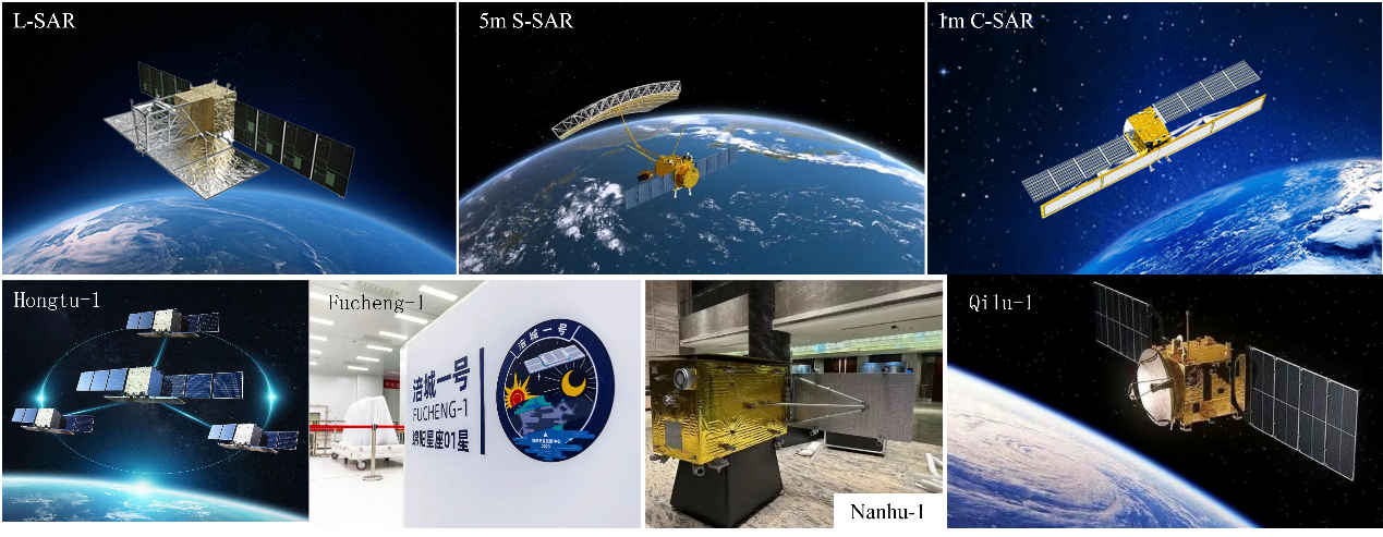
This training focuses on SAR satellites and their applications, covering various aspects. It will provide in-depth introductions to China’s L-SAR, 1-meter C-SAR, and 5-meter S-SAR public welfare SAR satellites and commercial SAR satellites such as Hongtu-1, Gaojing-2, Nanhu-1, Haixi-1, Fucheng-1, and Qilu-1. Additionally, it will extensively discuss the basic characteristics and parameters of those satellites. Furthermore, the training will involve the data processing workflow of domestically produced SAR satellites, with a particular emphasis on their typical applications in terrain mapping and surface deformation monitoring. By participating in this training, attendees will gain a comprehensive understanding of SAR satellites and their diverse applications across various fields, providing substantial support for their future work and research endeavors.
Point cloud processing with AI: theory, methods and applications
Dr. Bisheng Yang
Professor in GeoInformatics, Wuhan University
Director of LIESMARS
Co-Chair of Point Cloud Processing Workgroup in ISPRS Photogrammetry Commission
Dr. Bisheng Yang is a full Professor in Geoinformatics at Wuhan University, China, and director of State Key Laboratory of Information Engineering in Surveying, Mapping and Remote Sensing (LIESMARS). He obtained his Ph.D. degree in Photogrammetry and Remote Sensing in 2002 from Wuhan University. He holds Distinguished Young Scholars Professor. His research expertise include Lidar and UAV Photogrammetry, point cloud processing, and GIS and remote sensing applications. Dr. Yang has so far published more than 100 papers in peer-review journal articles, conference and workshop proceedings. He is Co-Chair of Point Cloud Processing Workgroup in Photogrammetry Commission of the International Society for Photogrammetry and Remote Sensing (ISPRS) from 2016-2024. He is Associate Editor of ISPRS Journal of Photogrammetry and Remote Sensing, and the recipient of a lot of national and international academic awards including Carl Pulfrich Award (2019).
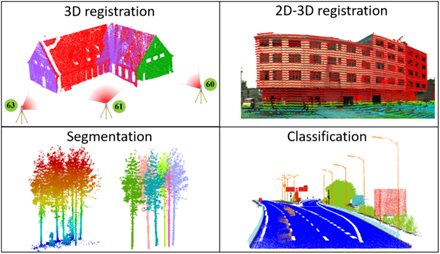
This training focuses on theory and applications of point cloud intelligence, covering various aspects. It will provide in-depth introductions to the Ubiquitous Point Cloud Theory, including point cloud registration, detection, segmentation, and modeling. Additionally, it will extensively discuss the point cloud processing software Point2Model. Furthermore, the training will involve the data processing workflow of the software Point2Model, with a particular emphasis on the typical applications in intelligent transportation systems, electricity power corridor inspection, forest carbon sink, etc. By participating in this training, attendees will gain a comprehensive understanding of point cloud intelligence and its diverse applications across various fields, providing substantial support for their future work and research endeavors.